 NSW Geoscience Metadata
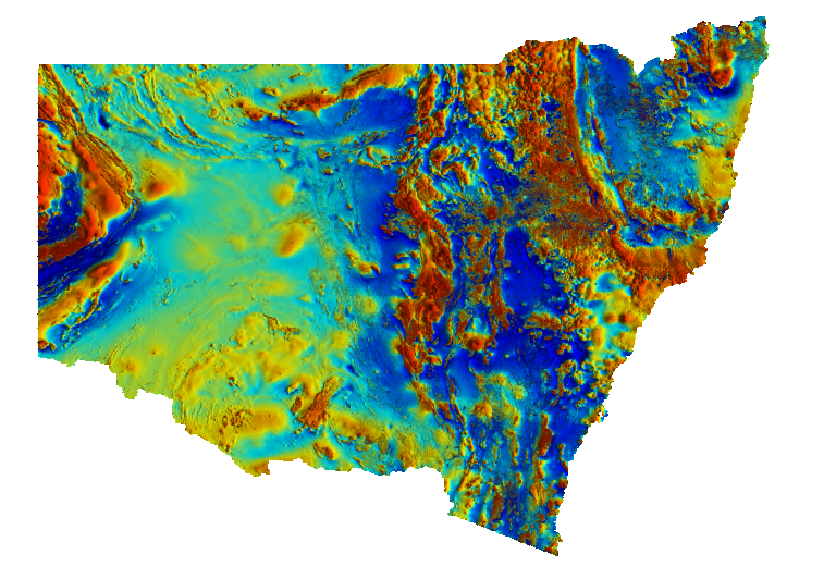
NSW Total Magnetic Intensity (TMI)
Pseudocolour image of total magnetic intensity (TMI) with a histogram-equalised colour-stretch. Cooler colours indicate lower magnetic intensity values and warmer colours represent higher values. The intensity layer is the TMI greyscale image enhanced by a 3x3 sun filter with the sun illumination set at 45 degrees elevation and 90 degrees azimuth. Variations in the magnetic field are caused by lithological factors, principally magnetite (and/or pyrrhotite) content. This Statewide image was generated by merging many individual airborne magnetic surveys.
Simple
Identification info
- Date (Revision)
- 2026-04-21
- Status
- Completed
Point of contact
- Topic category
-
- Geoscientific information
N
S
E
W
))
- Keywords (Theme)
-
- Geophysics
- Magnetics
- Statewide
- Keywords (Place)
-
- New South Wales
- Language
- English
Distribution Information
- Distribution format
-
- Web Map Service
Distributor
- OnLine resource
-
Download TMI 2026 ERS file (2.3GB)
GDA94
- OnLine resource
- Download TMI 2026 TIF file
- OnLine resource
-
Download TMI 2026 ERS file (2.3GB)
GDA2020
Resource lineage
- Statement
- This product represents the 2024 update to the NSW statewide magnetic merge. This version was rebuilt from the line data of all included surveys, and as of the 2020 release, incorporates high resolution open-file company data. MATTHEWS S.J. 2024. New South Wales Statewide magnetic merge, version 3.0 [Digital Dataset]. Geological Survey of New South Wales, Department of Primary Industries and Regional Development, Maitland. MATTHEWS S.J. 2022. New South Wales Statewide magnetic merge, version 2.0 [Digital Dataset]. Geological Survey of New South Wales, Department of Regional NSW, Maitland. MATTHEWS S.J. 2020. New South Wales Statewide magnetic merge, version 1.0 [Digital Dataset]. Geological Survey of New South Wales, Department of Regional NSW, Maitland.
- Hierarchy level
- Dataset
Reference System Information
- Reference system identifier
- EPSG:3857
Reference System Information
- Reference system identifier
- CRS:84
Metadata
- Metadata identifier
- urn:uuid/b5f4c2cb-46a2-4b98-a1ef-d12041f55c67
- Language
- English
- Character encoding
- UTF8
Type of resource
- Resource scope
- Dataset
- Metadata linkage
- https://geonetwork.geoscience.nsw.gov.au/geonetwork/srv/api/records/b5f4c2cb-46a2-4b98-a1ef-d12041f55c67
- Date info (Revision)
- 2026-04-21T08:48:49
- Date info (Creation)
- 2020-11-19T09:08:18
Metadata standard
- Title
- ISO 19115:2003/19139
- Edition
- 1.0
Overviews
geophys-imagery-geophys-mag-tmi.png
Spatial extent
N
S
E
W
Provided by

Associated resources
Not available