 NSW Geoscience Metadata
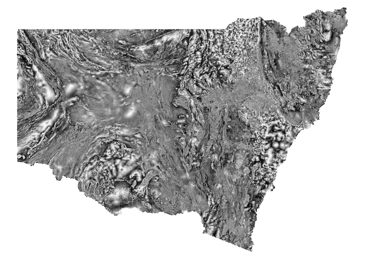
NSW Tilt angle filter of TMI RTP (Tilt TMI RTP)
Greyscale image of the tilt-angle filter (Tilt) of total magnetic intensity, reduced to the pole (TMI RTP). Darker tones indicate lower values and lighter tones represent higher values. Reduction to the pole filters magnetic anomalies to appear as if the Earth's magnetic field were locally vertical, as at the magnetic pole (assuming all magnetic sources are inductively magnetised). The Tilt filter produces a positive maximum over the centre of a magnetic source and is zero near the edge of the source, and is useful for tracing geological structure below variable depths of cover. Variations in the magnetic field are caused by lithological factors, principally magnetite (and/or pyrrhotite) content. This Statewide image was generated by merging many individual airborne magnetic surveys.
Simple
Identification info
- Date (Revision)
- 2026-04-21
- Status
- Completed
- Topic category
-
- Geoscientific information
))
- Keywords (Theme)
-
- Geophysics
- Magnetics
- Tilt filter
- Keywords (Place)
-
- New South Wales
- Language
- English
Distribution Information
- Distribution format
-
- Web Map Service
Distributor
OnLine resource
- Protocol
- undefined
- Name
- undefined
- Description
- undefined
- OnLine resource
-
Download Tilt TMI RTP 2026 ERS file (4.4GB)
GDA94
- OnLine resource
- Download Tilt TMI RTP 2026 TIF file
- OnLine resource
-
Download Tilt TMI RTP 2026 ERS file (4.4GB)
GDA2020
Resource lineage
- Statement
- This product represents the 2024 update to the NSW statewide magnetic merge. This version was rebuilt from the line data of all included surveys, and as of the 2020 release, incorporates high resolution open-file company data. MATTHEWS S.J. 2024. New South Wales Statewide magnetic merge, version 3.0 [Digital Dataset]. Geological Survey of New South Wales, Department of Primary Industries and Regional Development, Maitland. MATTHEWS S.J. 2022. New South Wales Statewide magnetic merge, version 2.0 [Digital Dataset]. Geological Survey of New South Wales, Department of Regional NSW, Maitland. MATTHEWS S.J. 2020. New South Wales Statewide magnetic merge, version 1.0 [Digital Dataset]. Geological Survey of New South Wales, Department of Regional NSW, Maitland.
- Hierarchy level
- Dataset
Reference System Information
- Reference system identifier
- EPSG:3857
Reference System Information
- Reference system identifier
- CRS:84
Metadata
- Metadata identifier
- urn:uuid/0f90e957-072c-4f77-9830-1fc849abeee2
- Language
- English
- Character encoding
- UTF8
Type of resource
- Resource scope
- Dataset
- Metadata linkage
- https://geonetwork.geoscience.nsw.gov.au/geonetwork/srv/api/records/0f90e957-072c-4f77-9830-1fc849abeee2
- Date info (Revision)
- 2026-05-01T09:07:29
- Date info (Creation)
- 2020-11-19T09:12:39
Metadata standard
- Title
- ISO 19115:2003/19139
- Edition
- 1.0
Overviews
Spatial extent
Provided by
