 NSW Geoscience Metadata
NSW Radiometric potassium(K)-thorium(Th)-uranium(U)
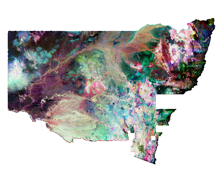
Ternary radioelement potassium(K)-thorium(Th)-uranium(U) channel data. The image was generated by merging many individual airborne surveys and is a red-green-blue (RGB) composite using a histogram-equalised colour-stretch for each of the three channels. The red, green and blue channels represent K, Th and U respectively. Mixed compositions are indicated by the proportional blend of the corresponding additive primary colours (e.g. yellow indicates the presence of both K and Th, magenta the presence of K and U while aqua indicates the presence of Th and U). Black indicates low concentrations and white represents high concentrations for all three radioelements. The distribution of radioelements reflects the geochemistry and mineralogy of the near-surface, which may constitute either bedrock or regolith materials. The NSW statewide grid DVD set includes K values in percent(%), Th values in parts per million (ppm) and U values in parts per million (ppm). This dataset is part of the Geological Survey NSW State Geophysics data set series.
Simple
- Date (Revision)
- 2025-05-05T00:00:02
- Status
- Completed
- Theme
-
-
WCS
-
ImageMosaic
-
Radio
-
- Topic category
-
- Geoscientific information
))
- Reference system identifier
-
EPSG:4326
- Reference system identifier
-
CRS:84
- Distribution format
-
- OnLine resource
-
Download Potassium per cent 2025 ERS file (4.1GB)
(
WWW:DOWNLOAD-1.0-http--download
)
- OnLine resource
-
Download Thorium ppm 2025 ERS file (4GB)
(
WWW:DOWNLOAD-1.0-http--download
)
- OnLine resource
-
Download Uranium ppm 2025 ERS file (4GB)
(
WWW:DOWNLOAD-1.0-http--download
)
- OnLine resource
-
DIGS product page
(
WWW:LINK-1.0-http--link
)
- OnLine resource
-
Download Potassium-Thorium-Uranium 2025 TIF file
(
WWW:DOWNLOAD-1.0-http--download
)
- Hierarchy level
- Dataset
- Statement
-
This is an RGB image of K–Th–U composite gridded data over NSW. The K, Th and U state-wide merged grids each have a grid cell size of 100×100 metres. The survey line-data was processed by stripping, suppression of noise by the Noise-Adjusted Singular Value Decompensation (NASVD) method detailed in Minty and McFadden (1998), where 256-channel data was available, and correction for radon, cosmic background and elevation. The survey data was then gridded using a minimum curvature algorithm. The individual survey grids were merged using polynomial corrections to minimise the differences in overlapping regions. Smaller errors were smoothed along joins. The most recently acquired surveys containing the highest resolution data were used in the merge. This process was repeated for each radioelement.
- File identifier
- 839768cabfe461972ff18f8850cf8f867c86197d XML
- Metadata language
- English
- Character set
- UTF8
- Hierarchy level
- Dataset
- Date stamp
- 2025-05-05T14:25:40
- Metadata standard name
-
ISO 19115:2003/19139
- Metadata standard version
-
1.0
Overviews
Spatial extent
Provided by
