 NSW Geoscience Metadata
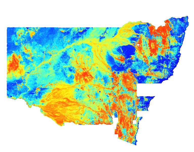
NSW Potassium Percentage (K%)
Pseudocolour image of the percentage of potassium (K%) in the upper 20 centimetres of the ground. Cooler colours indicate lower abundances of potassium and warmer colours represent higher abundances. Variations in potassium values are caused by varied mineral compositions in host rocks and soils. This statewide image was generated by merging many individual airborne radiometric surveys.
Simple
- Date (Revision)
- 2025-05-05T00:00:02
- Status
- Completed
- Theme
-
-
WCS
-
ImageMosaic
-
Radio
-
- Topic category
-
- Geoscientific information
N
S
E
W
))
- Reference system identifier
-
EPSG:4326
- Reference system identifier
-
CRS:84
- Distribution format
-
- OnLine resource
-
DIGS product page
(
WWW:LINK-1.0-http--link
)
- OnLine resource
-
Download Potassium per cent 2025 ERS file (4.1GB)
(
WWW:DOWNLOAD-1.0-http--download
)
- OnLine resource
-
Download Potassium percent 2025 TIF file
(
WWW:DOWNLOAD-1.0-http--download
)
- Hierarchy level
- Dataset
- File identifier
- 341e919f-8e36-47c8-8947-ce5e2b91287f XML
- Metadata language
- English
- Character set
- UTF8
- Hierarchy level
- Dataset
- Date stamp
- 2025-05-05T14:39:07
- Metadata standard name
-
ISO 19115:2003/19139
- Metadata standard version
-
1.0
Overviews
Spatial extent
N
S
E
W
Provided by

Associated resources
Not available