 NSW Geoscience Metadata
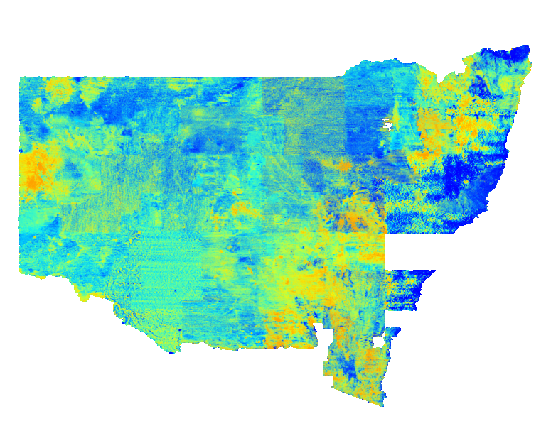
NSW Uranium Squared divided by Thorium (U2/Th)
Pseudocolour image of the ratio between uranium and thorium within the upper 20 centimetres of the ground. Cooler colours indicate lower abundances of uranium relative to thorium and warmer colours represent the opposite. Variations in U2/Th ratio are caused varied mineral compositions in host rocks and soils. This statewide image was generated by merging many individual airborne radiometric surveys.
Simple
- Date (Revision)
- 2025-05-05T00:00:02
- Status
- Completed
- Theme
-
-
WCS
-
ImageMosaic
-
Radio
-
- Topic category
-
- Geoscientific information
N
S
E
W
))
- Reference system identifier
-
EPSG:4326
- Reference system identifier
-
CRS:84
- Distribution format
-
- OnLine resource
-
Download Uranium Squared divided by Thorium (U2/Th) 2025 ERS file (4GB)
(
WWW:DOWNLOAD-1.0-http--download
)
- OnLine resource
-
Download Uranium squared divided by Thorium (U2/Th) 2025 TIF file
(
WWW:DOWNLOAD-1.0-http--download
)
- Hierarchy level
- Dataset
- File identifier
- 27ed4065-0be1-4935-bb14-74a90527ad41 XML
- Metadata language
- English
- Character set
- UTF8
- Hierarchy level
- Dataset
- Date stamp
- 2025-05-05T14:58:14
- Metadata standard name
-
ISO 19115:2003/19139
- Metadata standard version
-
1.0
Overviews
Spatial extent
N
S
E
W
Provided by

Associated resources
Not available