 NSW Geoscience Metadata
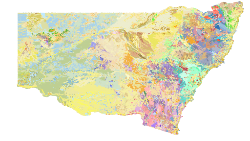
NSW Seamless Geology Version 2.5
The NSW Seamless Geology Project was originally a five-year initiative of the Geological Survey of New South Wales which commenced in late 2013 and aimed to provide a statewide compilation of the best available digital geological mapping data in an internally consistent format. The overarching aims of the NSW Seamless Geology Project were to: (i) compile the different original scales, formats and rock unit naming conventions into a consistent, statewide format; (ii) edge-match the geology across existing map sheets; and (iii) interpret the basement geology under cover. The resulting geodatabase comprises a series of layers which include: (i) solid basement geology; (ii) cover rocks (defined as undeformed and unmetamorphosed); (iii) Mesozoic igneous rocks; and (iv) Cenozoic sedimentary and igneous rocks.
Due to the size of the project, the work was divided into UTM zones, starting in the east with Zone 56, then moving west to Zone 54, and finishing with Zone 55. The western half of Zone 55 was completed in 2018, after which the results were merged with the previously completed Zones to produce version 1 of the NSW Seamless Geology dataset. Completion of this stage saw the end of phase 1 of the Seamless Geology Project, but it is intended that the Seamless Geology dataset will be continually updated and refined as new digital geological mapping data becomes available.
Updates to the Seamless Geology dataset generally occur on an annual basis. Version 2.5 is the 7th major update to the NSW Seamless Geology and was released in May 2025. This release includes: a new layer to capture Cenozoic ‘sub-basaltic gravels and deep leads’; significant upgrades to the mapping of numerous areas in the Lachlan Orogen (particularly the Coolac Serpentinite Belt, Gilmore Fault Zone, and the Eden-Merimbula area); a major update to the mapping of the Gunderbooka 1:100,000 map sheet area and the Port Macquarie–Laurieton area; and attribute updates, data additions, and minor error fixes to all layers.
NOTE: A substantial amount of overlay, erase and intersect geoprocessing of the original multi-layered Seamless Geology was undertaken to produce the single layer surface NSW Seamless Geology dataset. Due to small tolerance differences between different layers in the Seamless Geology dataset, this has, in some places, created small “sliver” polygons between boundaries common to more than one layer of the original multi-layered NSW Seamless Geology. This is a known issue with the current single layer Seamless Geology dataset and while some attempt has been made to resolve these issues, a number of small “sliver” polygons remain. Users are cautioned to be aware of this problem when using this dataset at high zoom levels (ie. under 1:1,000 scale) and to refer to the full Seamless Geology dataset for clarification.
Simple
- Date (Creation)
- 2025-04-23
- Date (Publication)
- 2025-05-09
- Edition
-
2.5
- Edition date
- 2025-05-09T00:00:00
Dr Gary Colquhoun
516 High Street
,Maitland
,New South Wales
,2320
,+61 2 4931 6700
https://www.resourcesandgeoscience.nsw.gov.au/
- Presentation form
- Digital map
- Other citation details
-
COLQUHOUN G.P., HUGHES K.S., DEYSSING L., BALLARD J.C., FOLKES C.B, PHILLIPS G., TROEDSON A.L. & FITZHERBERT J.A. 2023. New South Wales Seamless Geology dataset, version 2.3 [Digital Dataset]. Geological Survey of New South Wales, Department of Regional NSW, Maitland.
- Purpose
-
This data is part of the New South Wales Seamless Geology database, version 2.3, which is a statewide compilation of the best available digital geological mapping data in an internally consistent GIS format.
- Credit
-
Dataset Authors:
Colquhoun, G.P.
Hughes, K.S.
Deyssing, L.
Ballard, J.C.
Phillips G.
Troedson, A.L.
Folkes C.B.
Fitzherbert J.A.
- Status
- On going
Geological Survey of NSW
-Dr Gary Colquhoun
(Principal Geologist - Geospatial Group
)516 High Street
,Maitland
,New South Wales
,2320
,+61 2 4931 6700
https://www.resourcesandgeoscience.nsw.gov.au/
- Maintenance and update frequency
- annual
- Update scope
- Dataset
- Maintenance note
-
Scheduled updates to this dataset are planned as new data becomes available.
- Theme
-
-
GEOSCIENCES-Geology
-
- Keywords
-
-
Downloadable Data
-
- Access constraints
- License
- Use constraints
- Copyright
- Other constraints
-
Disclaimer
The information contained in this publication is based on knowledge and understanding at the time of writing (April 2025) and may not be accurate, current or complete. The State of New South Wales (including the DPIRD), the author and the publisher take no responsibility, and will accept no liability, for the accuracy, currency, reliability or correctness of any information included in the document (including material provided by third parties). Readers should make their own inquiries and rely on their own advice when making decisions related to material contained in this publication.
Copyright Statement
© State of New South Wales through DPIRD 2025. You may copy, distribute, display, download and otherwise freely deal with this publication for any purpose, provided that you attribute the Department of Primary Industries and Regional Development as the owner. However, you must obtain permission if you wish to charge others for access to the publication (other than at cost); include the publication in advertising or a product for sale; modify the publication; or republish the publication on a website. You may freely link to the publication on a departmental website.
Please give attribution in this form:
© State of New South Wales and the Department of Primary Industries and Regional Development 2025.
We also request that you observe and retain any copyright or related notices that may accompany this material as part of the attribution.
The Creative Commons licence does not apply to:
• the Government Coat of Arms, New South Wales Government logo, Department logo, or any other government-owned trademarks, logos and brands
• trade marks
• intellectual property (including copyright) owned by third parties including photographs, illustrations, artwork and maps
• personal information
• other materials specifically not provided under a Creative Commons Attribution 4.0 licence.
- Spatial representation type
- Vector
- Denominator
- 100000
- Metadata language
- English
- Character set
- UTF8
- Topic category
-
- Geoscientific information
- Environment description
-
Version 6.2 (Build 9200) ; Esri ArcGIS 10.4.0.5524
- Description
-
The dataset covers the land areas of New South Wales, Australia (including Lord Howe Island). A 10 km buffer into Queensland and Victoria is also included.
- Extent type code
- No
))
- Reference system identifier
-
EPSG
/4283
/8.3.4(3.0.1)
- Topology level
- Geometry only
- Geometric object type
- Composite
- Geometric object count
- 485
- Distribution format
-
-
ArcGIS
(10.4
) -
MapInfo
(11.0
) -
QGIS
(3.28
)
-
Geological Survey of NSW
-Dr Gary Colquhoun (Principal Geologist - Geospatial Group)
(Senior Geoscientist / GIS Analyst - Geospatial Group
)516 High Street
,Maitland
,New South Wales
,2320
,+61 2 4931 6700
https://www.resourcesandgeoscience.nsw.gov.au/
- OnLine resource
-
Project Homepage
(
WWW:LINK-1.0-http--link
)The Geological Survey of NSW Project page for the NSW Seamless Geology.
- OnLine resource
-
Download page: NSW Seamless Geology Data Package
(
WWW:LINK-1.0-http--link
)This product represents a seamless GIS compilation of the best available vector geology data for New South Wales. The data has been organised into a series of layers, or time slices, representing the major lithotectonic units of NSW. All layers have a consistent data structure and attribute schema from the GSNSW’s Statewide Geology Geodatabase (version 2). Base data (roads, railways, rivers, localities), outcrop location, and soil data are also provided.
- OnLine resource
-
MinView
(
WWW:LINK-1.0-http--link
)
- OnLine resource
-
Download page: NSW Seamless Geology Data Package Single Layer
(
WWW:LINK-1.0-http--link
)This a single layer version of the Seamless Geology, where the various time slices have been flattened into a single layer, effectively giving the surface geology only. Base data (roads, railways, rivers, localities), outcrop location, and soil data are also provided.
- OnLine resource
-
Seamless Geology changes v 2.5
(
WWW:LINK-1.0-http--link
)GS report detailing changes in version 2.5
- Hierarchy level
- Dataset
Absolute external positional accuracy
- Name of measure
-
GSNSW testing and editing
Conformance result
- Explanation
-
Geological data has mainly been sourced from existing 1:100 000 scale and 1:250 000 scale published geological maps. The accuracy of polygon boundaries is dependent on the original scale of mapping, and the date of mapping. More recent (GPS-era) 1:100 000 geology should be accurate to within 100m, whereas older 1:100 000 scale mapping should be accurate to within 500m. Geology compiled at 1:250 000 scale should be accurate to within 1000m. It should be noted that due to the absence of accurate base maps in this part of NSW at the time of compilation of these early 1:250,000 maps, many of the 1:250,000 geological from the 1960's to early 1970's were compiled on inaccurate base maps. As a result, errors of up to 1.2 km in location can occur. Attempts were made to correct this problem on many 1st edition 1:250,000 sheets (see lineage statement). All features were rubbersheeted to a re-georeferenced map (based on SPOT 5 satellite imagery) during December 2014 to March 2015 using thousands of control points. However, some inaccuracy of features may remain in this older 1:250,000 map in Zone 55 East and Zone 54.
- Pass
- Yes
gmd:DQ_NonQuantitativeAttributeCorrectness
- Name of measure
-
GSNSW testing and editing
Conformance result
- Explanation
-
Attribute data is the best available at the time of publication. All geological lines and points have a comprehensive set of attributes detailing the feature's origin, characteristics and accuracy. All geological units (polygons) are fully attributed with geological unit name, hierarchy, age, and lithological composition. Polygon attributes are based a table of NSW stratigraphic units (GSL_stratigraphy) which is administered and updated by the GSNSW.
- Pass
- Yes
Topological consistency
- Name of measure
-
GSNSW testing and editing
Conformance result
- Explanation
-
This dataset was compiled as an ESRI Geodatabase using ESRI's polygon and line topology verification, ensuring all geological unit (polygon) boundaries are overlain by corresponding geological contacts (lines). The data structure conforms to the Geoscience Australia standard for a digital geological map database. Systematic checks have been made of both unit and line topology throughout the entire data set. Topological checks have also been undertaken to ensure consistency between layers (ie. that boundaries present in two or more layers are coincident). NB. A substantial amount of overlay, erase and intersect geoprocessing of the original multi-layered Seamless Geology was undertaken to produce the single layer Seamless Geology dataset. Due to small tolerance differences between different layers in the Seamless Geology dataset, this has, in some places, created small “sliver” polygons between boundaries common to more than one layer of the original multi-layered Seamless Geology. This is a known issue with the current single layer Seamless Geology dataset and while some attempt has been made to resolve these issues, a number of small “sliver” polygons remain. Users are cautioned to be aware of this problem when using this dataset at high zoom levels (ie. under 1:1,000 scale) and to refer to the full Seamless Geology dataset for clarification.
- Pass
- Yes
Completeness omission
- Name of measure
-
GSNSW testing and editing
Conformance result
- Explanation
-
Geological data has mainly been sourced from existing 1:100 000 scale and 1:250 000 scale published geological maps. The accuracy of polygon boundaries is dependent on the original scale of mapping, and the date of mapping. More recent (GPS-era) 1:100 000 geology should be accurate to within 100m, whereas older 1:100 000 scale mapping should be accurate to within 500m. Geology compiled at 1:250 000 scale should be accurate to within 1000m. It should be noted that due to the absence of accurate base maps in this part of NSW at the time of compilation of these early 1:250,000 maps, many of the 1:250,000 geological from the 1960's to early 1970's were compiled on inaccurate base maps. As a result, errors of up to 1.2 km in location can occur. Attempts were made to correct this problem on many 1st edition 1:250,000 sheets (see lineage statement). All features were rubbersheeted to a re-georeferenced map (based on SPOT 5 satellite imagery) during December 2014 to March 2015 using thousands of control points. However, some inaccuracy of features may remain in this older 1:250,000 map in Zone 55 East and Zone 54.
- Pass
- Yes
- Statement
-
The NSW Seamless Geology Project team has compiled the best available geological data for the state into an internally consistent geodatabase. As part of the compilation process, contributing datasets were organised into a series of layers, or time slices, that represent the major lithotectonic subdivisions of the state’s geology. The data was then stitched/smoothed along existing map and dataset boundaries to create a seamless dynamic model of the geology of NSW. Important datasets and projects that contributed to the NSW Statewide Seamless Geology dataset are detailed below.
The Seamless Geology Project commenced in 2013 when merges of the best available datasets began to be assembled in the Statewide Geology Geodatabase (v.2) format. The source datasets for these merges are shown in the feature class “Seamless_V1_Source_Datasets” in this geodatabase. This merged dataset was divided into stratotectonic layers which were then edited by a small team of geologists, resolving edge-match issues and nomenclature problems between the geology of adjacent map sheets, and interpreting various layers under the cover of overlying layers. This produced a series of seamless geology layers which showed, for the first time, the actual distribution of rock units and structures, both in outcrop and under cover. These datasets were released progressively across the state as this work was completed, with three packages having been previously released; a Zone 56 dataset (Colquhoun, Phillips, Hughes, Deyssing, Fitzherbert & Troedson 2015), a Zone 54 dataset (Colquhoun, Phillips, Ballard, Hughes & Deyssing 2016) and a Zone 55 East dataset (Colquhoun, Deyssing, Ballard, Hughes & Troedson 2017). Zone 55 West was completed in mid-2018 but was not released as a separate dataset. Instead, the Zone 55 West data was merged with the previously released Seamless Geology datasets from the various zones and merged and harmonised to produce the first statewide Seamless Geology of NSW (version 1) in October 2018.
Updates to the Seamless Geology dataset have occurred every year since its release in 2018. These changes are detailed in a GS Report which can be accessed via the Download and links section above. Changes to the current version (v. 2.5) are detailed below:
What's new in Version 2.5 (May 2025)?
• Quaternary Lake, Pooncarie area – fixed a mistake in the Cenozoic Sedimentary Province layer around 142.9452990° -33.8148857° (GDA94) where a missing line from the Pooncarie 1:250,000 Geological Sheet had caused a polygon of Q_lps to not appear and was instead filled by Q_lp.
• Mount Frome Syncline and Pine Ridge Syncline – the large syncline southeast of Mudgee has been mistakenly labelled as the Mount Frome Syncline in previous versions of the NSW Seamless Geology. The original name Pine Ridge Syncline has been restored to the structure name attribute in the Seamless Geology as was originally intended by Colquhoun et al. (1997).
• Stephens Creek outcrop – an area of outcrop was added to the dataset approximately 2 km east of Stephens Creek around 141.5438886° -31.8309971° (GDA94).
• Thirlmere Lakes alluvium age – the Thirlmere Lakes alluvium has been moved from the Great Australian Basin layer to the Cenozoic Sedimentary Province layer and mapped as QH_l (Holocene lacustrine deposits).
• Packsaddle Syenite – outcrops of Jurassic syenite and orthosyenite near Packsaddle Trigonometrical Station in the Bancannia area, around 141.974353° -30.577955° (GDA94) were added to the Permian—Mesozoic Igneous Province layer.
• Sub basaltic gravels – to capture sub-basaltic gravels and deep leads correctly, a new layer has been added to the NSW Seamless Geology at version 2.5: Sub-CIP Cenozoic Sedimentary Province. The new layer has been placed below the Cenozoic Igneous Province layer (CIP) and above the Great Australian Basin (GAB) layer in the GIS packages and in MinView.
• Coolac Serpentinite Belt and Gilmore Fault Zone – the mapping of the Coolac Serpentinite Belt and the Gilmore Fault Zone (covering significant parts of the Tumut, Cootamundra, and Yarrangobilly 1:100,000 map sheet areas) has been extensively updated in version 2.5 of the Seamless Geology. The new mapping was largely derived from the work of Peter Stuart-Smith for his PhD and the Tumut seismic line geology traverse. The mapping was published extensively in the late 1980s and early 1990s.
• Eden–Merimbula Geology update – the Devonian geology of the Eden to Merimbula area (NSW far South Coast) received an upgrade in version 2.5 of the NSW Seamless Geology. The Merimbula Group and Boyd Volcanic Complex were left largely undifferentiated on the Bega 1:250,000 Geological Sheet (2nd edition) and previous versions of the NSW Seamless Geology. The constituent formation and member level units of these groups were added to the Seamless Geology version 2.5 based on the mapping of Steiner (1966), Hall (1960), Fergusson et al. (1979), Goldfields Exploration (1982), and Fergusson (2023).
• Bunga beds update – the Bunga beds of the Boyd Volcanic Complex in Mimosa Rocks National Park has been formalised as the Bunga Formation and the mapping of the unit has been upgraded based on numerous published geological maps of the unit by Cas et al. (1990), Cas and Bull (1993), Rickard and Love (2000), and Giordano and Cas (2001).
• Lachlan Orogen structure points plotting under cover – using several spatial queries during editing, it was noted that 1,126 structure points in the Lachlan Orogen layer plotted underneath younger layers – mostly the Cenozoic Sedimentary Province or the Cenozoic Igneous Province. In many cases, these errors have arisen when later or more detailed mapping was added to the Lachlan Orogen layer, but not the younger cover sequence layers. These errors were fixed by creating 'Voids' in the Cenozoic Sedimentary Province layer (i.e., outcrops), or moving boundaries slightly with the aid of ADS imagery and 5 m DEM data. In the case of older, inaccurately located points, the point was moved into a nearby outcrop area based on ADS imagery data.
• Andersons Tank Limestone Member and Bilpa Conglomerate – the geology of the Anderson Hill area (142.8064472° -31.5821764°, GDA94) 52 km west of Wilcannia, was updated using Figure 1 of Zhen et al. (2024). The Bilpa Conglomerate and Nuchea Conglomerate (Mutawintji Group) around 142.3799483° -31.8754559 (GDA94) were added to the Seamless Geology dataset based on descriptions by Greenfield et al. (2010).
• Hanaminno Limestone (Suoh) suppression – the Hanaminno Limestone was suppressed based on the recommendation of Percival and Zhen (2017) and the limestones of the area were reassigned to 'Hawkins Volcanics – limestone' (Sdoh_l).
• Gunderbooka mapping upgrade – version 2.5 of the NSW Seamless Geology includes a significant upgrade to the geology of the Gunderbooka 1:100,000 map sheet area in north central NSW. The updated mapping dataset (Deyssing and Trigg 2024) is significantly more detailed than the previous mapping over the Gunderbooka area and has resulted in changes to four layers in the Seamless Geology – the Cenozoic Sedimentary Province, Great Australian Basin, Western Devonian Basins, and Lachlan Orogen. The work also resulted in 14 new units, and 4 with updated codes or description changes.
• Malachis Hill Formation and Cheesemans Creek Formation – based on the recent work of Smith et al. (2024), the Cheesemans Creek Formation has been suppressed in favour of the earlier-named Malachis Hill Formation and all polygons formerly assigned to the Cheesemans Creek Formation have been reassigned to the Malachis Hill Formation.
• Structure Points upload from Field Observations database – 2,974 structure points were added to the NSW Seamless Geology dataset, mostly to the Lachlan Orogen, New England Orogen, and the Western Devonian Basins and Great Australian Basin layers.
• Fault attribution – Lachlan Orogen – the fault-related attributes for the Lachlan Orogen were completed during version 2.5. In version 2.4 (and previous versions) of the Seamless Geology, several hundred faults were without fault-related attributes, largely from recently added data.
• Port Macquarie–Laurieton area – the geology of the Port Macquarie-Laurieton area received a substantial upgrade during version 2.5, particularly the rock units of the New England Orogen (east of the Innes Estate Fault). This was based on an update (Och 2023) to earlier PhD thesis mapping of the area (Och 2007) using Nearmap coastal images.
• Thule Granite outcrop changes – 35 small voids (usually on small hills) were added to the Q_r residuum covering the Thule Granite to allow mapped quartz veins in Lachlan Orogen layer to be visible in the surface geology.
- File identifier
- 0a34a71d-6af9-47ba-80ed-8b31e499fe0e XML
- Metadata language
- English
- Character set
- UTF8
- Hierarchy level
- Dataset
- Hierarchy level name
-
dataset
- Date stamp
- 2025-05-01T15:49:11
- Metadata standard name
-
ISO 19139 Geographic Information - Metadata - Implementation Specification ISO 19139 Geographic Information - Metadata - Implementation Specification
- Metadata standard version
-
2007
Dr Gary Colquhoun
516 High Street
,Maitland
,New South Wales
,2320
,+61 2 4931 6700
https://www.resourcesandgeoscience.nsw.gov.au/
Overviews
Spatial extent
Provided by
