 NSW Geoscience Metadata
MapInfo
Type of resources
Topics
Keywords
Contact for the resource
Provided by
Years
Formats
Representation types
Update frequencies
status
Scale
-

The NSW Seamless Geology Project is a five-year initiative of the Geological Survey of New South Wales which commenced in late 2013 and aims to provide a statewide compilation of the best available digital geological mapping data in an internally consistent format. The overarching aims of the NSW Seamless Geology Project were to: (i) compile the different original scales, formats and rock unit naming conventions into a consistent, statewide format; (ii) edge-match the geology across existing map sheets; and (iii) interpret the basement geology under cover. The resulting geodatabase comprises a series of layers which include: (i) solid basement geology; (ii) cover rocks (defined as undeformed and unmetamorphosed); (iii) Mesozoic igneous rocks; and (iv) Cenozoic sedimentary and igneous rocks. Due to the size of the project, the work was divided into UTM zones, starting in the east with Zone 56, then moving west to Zone 54, and finishing with Zone 55. The western half of Zone 55 was completed in 2018, after which the results were merged with the previously completed Zones to produce version 1 of the NSW Seamless Geology dataset. Completion of this stage saw the end of phase 1 of the Seamless Geology Project, but it is intended that the Seamless Geology dataset will be continually updated and refined as new digital geological mapping data becomes available. Version 2 is the 2nd major update to the NSW Seamless Geology and was released in May 2020. This release includes: final data from the East Riverina Mapping Project; updates to the geology of several areas in the Lachlan Orogen; approximately 11,000 new structure points in the Lachlan Orogen and Curnamona Province; detailed revision of the Cenozoic Igneous Province; detailed mapping of the Newcastle Coal Measures; and extensive upgrades to the RockUnit polygon attribute table. The geology of Lord Howe Island is also included for the first time. A single layer version of the Seamless Geology dataset has been created to give a view of the New South Wales surface geology only by removing all the data from overlapped feature classes of the full NSW Seamless Geology dataset and merging the remaining data into a single feature class. As well as giving a view of the surface geology that is faster to display than the full NSW Seamless Geology dataset, the single layer NSW Seamless Geology dataset is also useful for performing statewide queries that would otherwise have to be performed multiple times on the full multi-layered New South Wales Seamless Geology dataset. Version 2.1 is the 3rd major update to the NSW Seamless Geology and was released in May 2021. This release includes: the NSW Metamorphic dataset; an upgrade of the geology of the Cenozoic Murray Basin (southwest New South Wales); an upgrade of the geology of the Sydney Basin and Mesozoic intrusions of the Illawarra region; changes to the boundaries of several depo-centres of the Darling Basin; over 50,000 trendlines and dykes were added to the Curnamona Province data in the Broken Hill area; the geology of Kinchega National Park, near Menindee, has been reinterpreted and updated using ADS imagery and radiometric data; and updates were made to the stratigraphy and nomenclature of the Fifield Suite (Lachlan Orogen). This release also features many new additions to the RockUnit attribute table, including an "Ultramafic" field, and new or updated magmatic fertility attributes (Lachlan Orogen only). NOTE: A substantial amount of overlay, erase and intersect geoprocessing of the original multi-layered Seamless Geology was undertaken to produce the single layer surface NSW Seamless Geology dataset. Due to small tolerance differences between different layers in the Seamless Geology dataset, this has, in some places, created small “sliver” polygons between boundaries common to more than one layer of the original multi-layered NSW Seamless Geology. This is a known issue with the current single layer Seamless Geology dataset and while some attempt has been made to resolve these issues, a number of small “sliver” polygons remain. Users are cautioned to be aware of this problem when using this dataset at high zoom levels (ie. under 1:1,000 scale) and to refer to the full Seamless Geology dataset for clarification.
-

The NSW Seamless Geology Project is a five-year initiative of the Geological Survey of New South Wales which commenced in late 2013 and aims to provide a statewide compilation of the best available digital geological mapping data in an internally consistent format. The overarching aims of the NSW Seamless Geology Project were to: (i) compile the different original scales, formats and rock unit naming conventions into a consistent, statewide format; (ii) edge-match the geology across existing map sheets; and (iii) interpret the basement geology under cover. The resulting geodatabase comprises a series of layers which include: (i) solid basement geology; (ii) cover rocks (defined as undeformed and unmetamorphosed); (iii) Mesozoic igneous rocks; and (iv) Cenozoic sedimentary and igneous rocks. Due to the size of the project, the work was divided into UTM zones, starting in the east with Zone 56, then moving west to Zone 54, and finishing with Zone 55. The western half of Zone 55 was completed in 2018, after which the results were merged with the previously completed Zones to produce version 1 of the NSW Seamless Geology dataset. Completion of this stage saw the end of phase 1 of the Seamless Geology Project, but it is intended that the Seamless Geology dataset will be continually updated and refined as new digital geological mapping data becomes available. Version 2.3 is the 5th major update to the NSW Seamless Geology and was released in May 2023. This release includes: the addition of a "Mafic" attribute field; significant upgrades to the geology of numerous areas in the Lachlan Orogen, Permian-Mesozoic Igneous Province, and Permo-Triassic Basins; and attribute updates and minor error fixes to all layers. NOTE: A substantial amount of overlay, erase and intersect geoprocessing of the original multi-layered Seamless Geology was undertaken to produce the single layer surface NSW Seamless Geology dataset. Due to small tolerance differences between different layers in the Seamless Geology dataset, this has, in some places, created small “sliver” polygons between boundaries common to more than one layer of the original multi-layered NSW Seamless Geology. This is a known issue with the current single layer Seamless Geology dataset and while some attempt has been made to resolve these issues, a number of small “sliver” polygons remain. Users are cautioned to be aware of this problem when using this dataset at high zoom levels (ie. under 1:1,000 scale) and to refer to the full Seamless Geology dataset for clarification.
-
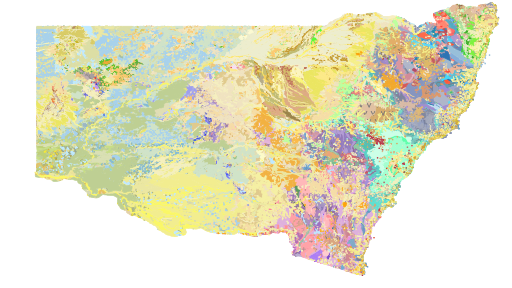
The NSW Seamless Geology Project was originally a five-year initiative of the Geological Survey of New South Wales which commenced in late 2013 and aimed to provide a statewide compilation of the best available digital geological mapping data in an internally consistent format. The overarching aims of the NSW Seamless Geology Project were to: (i) compile the different original scales, formats and rock unit naming conventions into a consistent, statewide format; (ii) edge-match the geology across existing map sheets; and (iii) interpret the basement geology under cover. The resulting geodatabase comprises a series of layers which include: (i) solid basement geology; (ii) cover rocks (defined as undeformed and unmetamorphosed); (iii) Mesozoic igneous rocks; and (iv) Cenozoic sedimentary and igneous rocks. Due to the size of the project, the work was divided into UTM zones, starting in the east with Zone 56, then moving west to Zone 54, and finishing with Zone 55. The western half of Zone 55 was completed in 2018, after which the results were merged with the previously completed Zones to produce version 1 of the NSW Seamless Geology dataset. Completion of this stage saw the end of phase 1 of the Seamless Geology Project, but it is intended that the Seamless Geology dataset will be continually updated and refined as new digital geological mapping data becomes available. Updates to the Seamless Geology dataset generally occur on an annual basis. Version 2.5 is the 7th major update to the NSW Seamless Geology and was released in May 2025. This release includes: a new layer to capture Cenozoic ‘sub-basaltic gravels and deep leads’; significant upgrades to the mapping of numerous areas in the Lachlan Orogen (particularly the Coolac Serpentinite Belt, Gilmore Fault Zone, and the Eden-Merimbula area); a major update to the mapping of the Gunderbooka 1:100,000 map sheet area and the Port Macquarie–Laurieton area; and attribute updates, data additions, and minor error fixes to all layers. NOTE: A substantial amount of overlay, erase and intersect geoprocessing of the original multi-layered Seamless Geology was undertaken to produce the single layer surface NSW Seamless Geology dataset. Due to small tolerance differences between different layers in the Seamless Geology dataset, this has, in some places, created small “sliver” polygons between boundaries common to more than one layer of the original multi-layered NSW Seamless Geology. This is a known issue with the current single layer Seamless Geology dataset and while some attempt has been made to resolve these issues, a number of small “sliver” polygons remain. Users are cautioned to be aware of this problem when using this dataset at high zoom levels (ie. under 1:1,000 scale) and to refer to the full Seamless Geology dataset for clarification.
-

The NSW Seamless Geology Project was originally a five-year initiative of the Geological Survey of New South Wales which commenced in late 2013 and aimed to provide a statewide compilation of the best available digital geological mapping data in an internally consistent format. The overarching aims of the NSW Seamless Geology Project were to: (i) compile the different original scales, formats and rock unit naming conventions into a consistent, statewide format; (ii) edge-match the geology across existing map sheets; and (iii) interpret the basement geology under cover. The resulting geodatabase comprises a series of layers which include: (i) solid basement geology; (ii) cover rocks (defined as undeformed and unmetamorphosed); (iii) Mesozoic igneous rocks; and (iv) Cenozoic sedimentary and igneous rocks. Due to the size of the project, the work was divided into UTM zones, starting in the east with Zone 56, then moving west to Zone 54, and finishing with Zone 55. The western half of Zone 55 was completed in 2018, after which the results were merged with the previously completed Zones to produce version 1 of the NSW Seamless Geology dataset. Completion of this stage saw the end of phase 1 of the Seamless Geology Project, but it is intended that the Seamless Geology dataset will be continually updated and refined as new digital geological mapping data becomes available. Updates to the Seamless Geology dataset generally occur on an annual basis. Version 2.6 is the 8th major update to the NSW Seamless Geology and was released in 2026. This release includes major remapping of the northern Rockley–Gulgong Volcanic Belt; a significant upgrade to the mapping of Broughton Island; significant updates to the Lachlan Orogen and Cenozoic Sedimentary Province in the Canbelego 1:100,000 map sheet area; and attribute updates, data additions, and minor error fixes to all layers. NOTE: A substantial amount of overlay, erase and intersect geoprocessing of the original multi-layered Seamless Geology was undertaken to produce the single layer surface NSW Seamless Geology dataset. Due to small tolerance differences between different layers in the Seamless Geology dataset, this has, in some places, created small “sliver” polygons between boundaries common to more than one layer of the original multi-layered NSW Seamless Geology. This is a known issue with the current single layer Seamless Geology dataset and while some attempt has been made to resolve these issues, a number of small “sliver” polygons remain. Users are cautioned to be aware of this problem when using this dataset at high zoom levels (ie. under 1:1,000 scale) and to refer to the full Seamless Geology dataset for clarification.
-

The NSW Seamless Geology Project was originally a five-year initiative of the Geological Survey of New South Wales which commenced in late 2013 and aimed to provide a statewide compilation of the best available digital geological mapping data in an internally consistent format. The overarching aims of the NSW Seamless Geology Project were to: (i) compile the different original scales, formats and rock unit naming conventions into a consistent, statewide format; (ii) edge-match the geology across existing map sheets; and (iii) interpret the basement geology under cover. The resulting geodatabase comprises a series of layers which include: (i) solid basement geology; (ii) cover rocks (defined as undeformed and unmetamorphosed); (iii) Mesozoic igneous rocks; and (iv) Cenozoic sedimentary and igneous rocks. Due to the size of the project, the work was divided into UTM zones, starting in the east with Zone 56, then moving west to Zone 54, and finishing with Zone 55. The western half of Zone 55 was completed in 2018, after which the results were merged with the previously completed Zones to produce version 1 of the NSW Seamless Geology dataset. Completion of this stage saw the end of phase 1 of the Seamless Geology Project, but it is intended that the Seamless Geology dataset will be continually updated and refined as new digital geological mapping data becomes available. Updates to the Seamless Geology dataset generally occur on an annual basis. Version 2.4 is the 6th major update to the NSW Seamless Geology and was released in May 2024. This release includes: a major upgrade to the geological mapping of the Sydney Basin; significant upgrades to the mapping of numerous areas in the Permian-Mesozoic Igneous Province and the Lachlan Orogen (particularly the Cadia Valley, Lake Cowal and Quarry Creek areas); and attribute updates, data additions, and minor error fixes to all layers. NOTE: A substantial amount of overlay, erase and intersect geoprocessing of the original multi-layered Seamless Geology was undertaken to produce the single layer surface NSW Seamless Geology dataset. Due to small tolerance differences between different layers in the Seamless Geology dataset, this has, in some places, created small “sliver” polygons between boundaries common to more than one layer of the original multi-layered NSW Seamless Geology. This is a known issue with the current single layer Seamless Geology dataset and while some attempt has been made to resolve these issues, a number of small “sliver” polygons remain. Users are cautioned to be aware of this problem when using this dataset at high zoom levels (ie. under 1:1,000 scale) and to refer to the full Seamless Geology dataset for clarification.