 NSW Geoscience Metadata
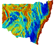
NSW Bouguer Gravity
Pseudocolour image of Bouguer gravity with a histogram-equalised colour stretch. Cooler colours indicate lower Bouguer gravity values and warmer colours represent higher values. The intensity layer is the Bouguer gravity greyscale image enhanced by a 3x3 sun filter with the sun illumination set at 45 degrees elevation and 90 degrees azimuth. Bouguer gravity compensates for variations in latitude, 'free-air' elevation and Bouguer correction (assuming a crustal density of 2.67 T/m³).
Attention: Please ensure your version of the NSW gravity merges contains the date ‘2024-10-30’ in their filename. An update was made to remedy location errors in the initial release. Apologies for any inconvenience.
Simple
Identification info
- Date (Revision)
- 2025-05-09
- Status
- Completed
- Topic category
-
- Geoscientific information
N
S
E
W
))
- Keywords (Theme)
-
- Geophysics
- Gravity
- Isostatic Bouger
Distribution Information
- Distribution format
-
- OnLine resource
- Download ERS file ( Air Only)
- OnLine resource
- Download TIF file (Air only)
Resource lineage
- Statement
- This edition of the NSW statewide gravity merge is a compilation of best available airborne and ground data, comprising roughly 80% airborne and 20% ground. AIR1027 and AIR1030 comprise the airborne data, with the ground data clipped from Geoscience Australia’s ANGD dataset. These data were gridded with a cell size of 500x500 metres before being corrected for isostasy following the method outlined in Spence and Musgrave (2006). The units for the data are μms⁻². This product represents the 2024 update to the NSW statewide gravity merge. This version incorporates the recently acquired statewide airborne dataset. It will represent a platform for future iterative updates. MATTHEWS S.J. 2024. New South Wales Statewide gravity merge, version 2.0 [Digital Dataset]. Geological Survey of New South Wales, Department of Primary Industries and Regional Development NSW, Maitland MATTHEWS S.J. 2020. New South Wales Statewide gravity merge, version 1.0 [Digital Dataset]. Geological Survey of New South Wales, Department of Regional NSW, Maitland
- Hierarchy level
- Dataset
Reference System Information
- Reference system identifier
- EPSG:4326
Reference System Information
- Reference system identifier
- CRS:84
Metadata
- Metadata identifier
- urn:uuid/ce076e1f-13cb-4c7d-a4f5-aa4eec0791cf
- Language
- English
- Character encoding
- UTF8
Type of resource
- Resource scope
- Dataset
- Metadata linkage
- https://geonetwork.geoscience.nsw.gov.au/geonetwork/srv/api/records/ce076e1f-13cb-4c7d-a4f5-aa4eec0791cf
- Date info (Revision)
- 2025-05-09T09:36:09
- Date info (Creation)
- 2020-09-11T15:02:05
Metadata standard
- Title
- ISO 19115:2003/19139
- Edition
- 1.0
Overviews
Bouguer_gravity.png
Spatial extent
N
S
E
W
Provided by

Associated resources
Not available